Surface albedo determines the shortwave radiation balance, which is the largest energy balance component, especially on continental glaciers. Spatial and temporal assessments of albedo of ice and snow are required for modelling of glacier mass balance. Although albedo values could be derived from satellite data, terrestrial photography or parametrization schemes, ground-based measurements are needed for calibration and validation of these approaches.
Nevertheless, in many mountain regions ground-based data on glacier surface albedo are scarce or even absent. This is true for the highly glaciered Tien Shan mountains, which are surrounded by arid lowlands. Glacier meltwater is a vital component of river runoff and data on albedo is among many parameters that can help to adapt the local economy to climate change.
Is the SP Lite2 albedometer the best choice for field campaigns in high mountains?
In August, 2015 we performed real ground-based measurements of albedo on seven glaciers in the headwaters of the Naryn River, located in the Eastern part of Kyrgyzstan in the Inner Tien Shan. We measured albedo at many points of each glacier, considering different types of surface; clean or dirty ice, superimposed ice, firn and snow.
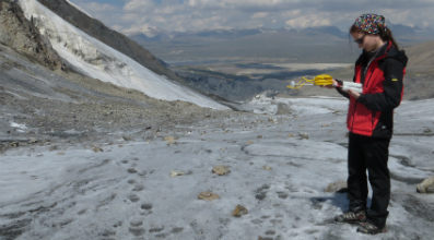 Alyona Shpuntova with the SP Lite2 albedometer
The number of measuring points varied from 40 to more than 100, depending on the glacier area and the survey scale. During this field campaign we covered more than 100 km over several days at altitudes above 4000 m and with significant height differences.
Thus, the choice of albedometer was very important for success of the project; it should be compact, easy to use, precise and with a short response time. Furthermore, it was necessary to read and save the measured values of incoming and reflected short-wave radiation.
Upon the advice of specialists from Kipp & Zonen we chose a pair of SP Lite2 pyranometers and a mounting rod, to make a light weight albedometer, in combination with two METEON data loggers. After the field campaign we can say that this combination is probably the best solution for real measurements of albedo in high mountains.
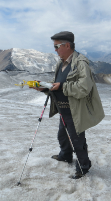 Ryskul Usubaliev during fieldwork
Albedo of continental glaciers could be lower than supposed earlier.
Our preliminary results were surprising. Typically, the albedo of glacier surfaces can range from more than 0.9 (90% reflection) for fresh snow down to around 0.2 for dirty ice. According to our data most of the ice in the Inner Tien Shan has albedo within the range 0.12 to 0.25, but at some points, where ice was very dirty, the albedo varied from 0.1 to 0.15. How could it be explained?
A high altitude semi-arid landscape with scarce vegetation, in combination with cryogenic weathering and strong winds, leads to intensive Aeolian transport of dust. Dust is transported not just from the glacier surroundings but also from deserts near to the Tien Shan. Dusty mists continued over several decades were registered in the Naryn headwaters in the 19th century.
Extremely warm weather before and during our measurements also led to a lowering of albedo. Although there is a temptation to explain low values of albedo as a result of mining in the area, we noted that similar values of albedo of dirty ice were registered by V. Konovalov and I. Lebedeva on glaciers in the Western Tien Shan in 1982. Therefore, we can assume that the albedo of glacial ice in Tien Shan is lower than considered earlier, especially during warm summers.
By Dmitry Petrakov, Moscow State University, Faculty of Geography
The team:
Dmitry Petrakov, Nikolay Kovalenko and Alyona Shpuntova, Moscow State University
Ryskul Usubaliev, Central Asian Institute for Applied Geosciences
Go to www.eng.geogr.msu.ru to find out more about the Faculty of Geography
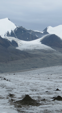 Dust cones at Petrov Glacier surface