Kilimanjaro encompasses more than 3,000 km2 of northern Tanzania, with a vertical relief of 5,000 meters. Spending time on the mountain reveals why 50,000 people endure the crowds and expense each year, for Kilimanjaro is simply fascinating in numerous respects. Among these are: a human culture which has adapted and developed over millennia, and in many respects remains intact; the friendly, cheerful people working on the mountain, who outnumber tourists ~4:1; the zonation of ecological assemblages which often change with every meter of ascent; the dramatic diurnal cycles characterizing Kilimanjaro’s climate, which also changes sharply with elevation; and the incredible panoramic view from high on the mountain, typically looking down onto understory clouds but occasionally to distant peaks, lakes, and human development below. Rarely is the surrounding atmosphere quiescent; intense radiation drives convection above the slopes, which expands both spatially and vertically during the day, until airflow from another direction dries out the rising parcels. These features and processes are enchanting.
The summit itself is also huge, comprised of a more-or-less flat caldera measuring more than 2 km in diameter. Multiple, concentric ‘craters’ are but one reminder that this is a volcano, along with elemental sulfur deposits, emissions of sulfur dioxide, and steam vents – all providing clear evidence that volcanic activity has not ceased there.
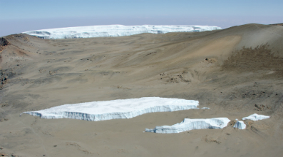
Figure 1. Panorama across the summit caldera looking over the Furtwängler Glacier remnants to the Northern Ice Field (~2.3 km), from near Uhuru Peak.
Hemingway’s “unbelievably white in the sun” is not hyperbole, at least at times. There is little doubt he was referring to the summit glaciers, the ragged fringe of an ice cap which once encircled the broad caldera and spilled down onto the flanks. The area covered by ice is greatly diminished from the late 19th century extent, yet the glaciers remain starkly beautiful against the dark volcanic ash and deep-blue sky beyond. Their color changes with the lighting, becoming brilliant white when albedo is high and intense incoming solar radiation is reflected back.
Kilimanjaro’s glaciers are still over 45 meters thick in places, and preserve a record of environmental change which does not exist within ice anywhere else on the African continent. In February 2000 Lonnie Thompson (Ohio State University) drilled 6 ice cores at the summit, and from these developed a record which may span nearly 12,000 years. At the time of drilling, no systematic meteorological measurements existed from the summit, with only a few anecdotal temperature measurements. Indeed, all existing climate stations at the time were ~4,000 meters lower in elevation, and these data revealed nothing about temperature, radiation, airflow or precipitation high on the mountain.
To provide a physical basis upon which to interpret the ice cores, an automated weather station (AWS) was installed during drilling, near the deepest site. The principle objective has expanded from a short-term experiment to one of comprehensively characterizing current summit climate, which includes considerable inter-annual variability. Measurements are proving valuable in understanding the long-term history of Kilimanjaro’s glaciers, the ice-core records, and the larger-scale causal mechanisms driving environmental changes currently underway in east Africa.
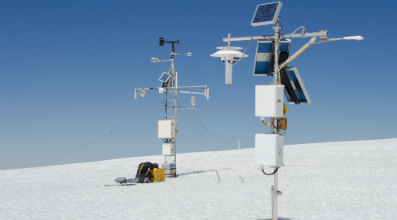
Figure 2. Automated weather stations (AWS) on Kilimanjaro’s Northern Ice Field. The original AWS installed in February 2000 is on the left, including an albedometer and pyrgeometer; another tower with a net radiometer and supplemental instrumentation was added in 2010 and 2012.
After 14 years, the glacier AWS has proven successful beyond all expectations. Although maintaining the station on a constantly-changing glacier surface requires considerable effort, Kilimanjaro provides a fixed platform for continuous measurement of the tropical troposphere. Unlike transient radiosonde observations at this level, the AWS allows measurement of a broader suite of variables (e.g., radiation) and with much higher frequency. The initial station installed in 2000 included sensors to measure wind speed & direction, incoming & reflected solar radiation, downward longwave radiation, surface temperature, aspirated & naturally-ventilated air temperature & humidity, snow accumulation & ablation (i.e., ultrasonic distance), and barometric pressure (figure 2). Four-hourly values from most of these measurements are transmitted by the station via Argos satellite telemetry, which has performed flawlessly over the entire period.
In 2010 and 2012, additional sensors were installed which are compatible with those of the USCRN (Climate Reference Network), including a continuously-ventilated radiation shield housing several PRT temperature sensors and a high-accuracy, warmed humidity sensor. Also added were an infrared temperature transducer and an integrated, four-component net radiometer. Through improved measurement accuracy, these new sensors are yielding a comprehensive new view of summit climate.
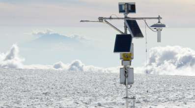
Figure 3. AWS on Kilimanjaro’s Northern Ice Field at 5,775 m, with net radiometer (left-hand side) and fan-aspirated shield for temperature & humidity sensor (right). Mt. Meru is 70 km distant in the background.
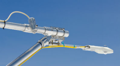
Figure 4. CNR 4 Net radiometer (Kipp & Zonen) and an infrared temperature transducer (Apogee) installed on Kilimanjaro in Oct. 2012, both of which view the same area of glacier surface.
The success of climate measurements on the Northern Ice Field is due to a variety of factors. Some of these were anticipated, such as the mountain’s free-standing nature and high elevation, while others were fortuitous:
- Airflow over the broad, dome-shaped glacier is minimally disrupted by topography. To the east, which is the predominant wind direction, the relatively-flat snow and ice surface extends ~800 m from the AWS. Wind speed averaging 6 m/s provides good ventilation of instruments – improving accuracy – yet high wind loading on the tower is rare.
- Air at Kilimanjaro’s summit is typically dry, with vapor pressure averaging ~ 2 hPa and annual precipitation less than 300 mm. Frequently, stratiform and/or convective clouds develop around the mountain, occasionally reaching even higher altitude, while at the same time, clear sky prevails over the summit caldera. This donut-shaped pattern is not visible from the surrounding plains, yet is an important feature of summit climate. Due to the dry air and intense incoming solar radiation, rime ice development on instruments is infrequent, as timelapse camera images demonstrate. Even during the two seasonally-wet periods each year, rime that does develop typically sublimates and/or falls off within hours to days (e.g., figure 5, middle).
- Air quality on the Northern Ice Field is very high, which maintains instrument accuracy between service intervals and calibrations. Despite the large area of exposed caldera, a recent analysis of trace-elements in one of the ice cores found very low concentrations of insoluble particles.
- Intense solar radiation provides an abundant power resource, via photovoltaics.
- Long-term station data in east Africa are almost exclusively from elevations at least 4,000 m lower than the Kilimanjaro AWS – beneath a persistent inversion layer – and are therefore much less representative of both summit climate and the free atmosphere.
- Beneath the AWS, literally, is an environmental archive preserved by the glacier, currently believed to have begun forming nearly 12,000 years ago. Modern climate measurements are aiding in the interpretation of the ice core record, through improved understandings of how the glacier records climate.
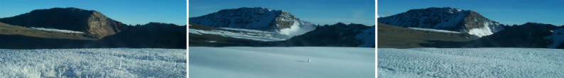
Figure 5. Three timelapse-camera views from Kilimanjaro’s Northern Ice Field, illustrating the variability of glacier surface texture and albedo; note ablation stake in foreground. Left to right: 12 October 2009, 11 January and 3 February 2010, all at 18:00 local time.
Our newest measurements from the recently-added net radiation sensor are particularly exciting. Until adding this instrument each radiation component was measured separately, because engineering and spatial considerations required situating instruments close to the tower. Being too prominently within the instruments’ fields of view, the tower adversely influenced measurements. Now, with the lightweight, integrated sensor, measurements are being made further from the tower and better represent the four variables (figure 4). In addition, any leveling adjustment during fieldwork at the site (5,775 m) consumes far less time than that required in leveling four different instruments.
The first year with an integrated net radiometer at the site demonstrates the intensity of radiation on Kilimanjaro, as median incoming shortwave at mid-day – over all days of the year – was nearly 90% of that at the top of the atmosphere. Net shortwave radiation varied widely, due to control of reflectivity by surface albedo which ranged from 0.31 during the dry season to 0.90 following snowfall. In general, measurements reveal a very close correspondence between the variability of snowfall/snow-surface age and net solar radiation. Figure 6 demonstrates the sensitivity of net shortwave receipt to snowfall (e.g., late-September event), yet also illustrates the influence of snowfall magnitude – as shown by the gradual increase following the March-May “long rains”. During the extended dry season of June into September, gradually lowering albedo as the snow ages causes almost a doubling of net shortwave radiation, resulting in continuous ablation through the coldest months of the year (not shown).
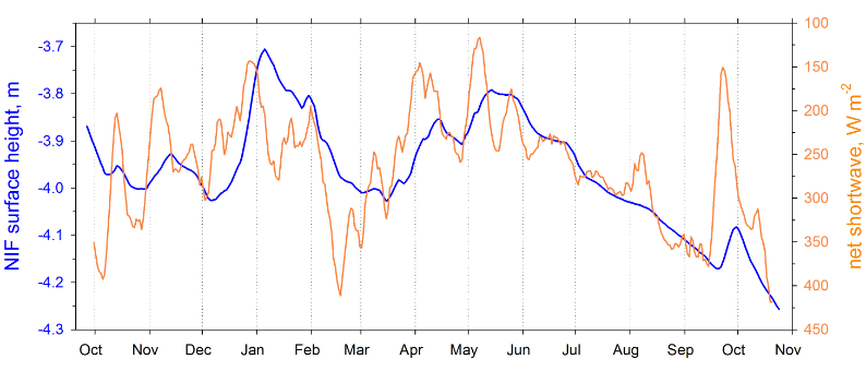 Figure 6. Timeseries of glacier surface height and net shortwave radiation on the Northern Ice Field (NIF), with both shown as 7-day running averages. Datum for surface height is 25 Feb. 2000. Note reversed y-axis scale for radiation.
These new radiation measurements confirm that the variability of net radiation is most closely controlling the “health” of these glaciers. Earlier measurements, and modeling with collaborators at the University of Innsbruck (Austria), showed that Kilimanjaro glaciers are indeed primarily sensitive to the variability of snowfall amount and timing. One obvious reason for this is that snowfall adds mass to the glaciers; more importantly, it is through the governance of surface brightness (i.e., albedo) which controls the extent to which solar radiation is reflected rather than absorbed (figure 5). When radiation is absorbed at the glacier surface, this energy is available to drive melt and sublimation, both of which remove mass from the glaciers and are causing shrinkage.
Details of high-elevation climate are poorly documented, yet many tropical mountains support a high degree of biodiversity. However, some ecological communities will be unable to migrate upward as quickly as the troposphere warms. Kilimanjaro is affording an opportunity to make a full suite of climate measurements high above any others that exist in the region, and thus serving as a valuable tool for assessing model performance as well as measurements made at larger spatial scales by radiosondes, satellites, and Reanalysis data. Hopefully, Kilimanjaro measurements can continue until inter-annual variability is better resolved, and in the meantime, collaborative investigations will continue and expand.
Operating the Kilimanjaro AWS has been a fascinating endeavor, possible only with assistance from numerous collaborators and assistants. Gratitude is particularly due Raymond Bradley in the Climate System Research Center at the University of Massachusetts Amherst, Thomas Mölg and Georg Kaser at the University of Innsbruck, as well as Tanzanian personnel on the mountain and in governmental agencies (esp. TAWIRI, TANAPA, and KINAPA). This research has been primarily supported by the U.S. National Science Foundation (NSF); any opinions, findings, and conclusions or recommendations expressed in this material are those of the author and do not necessarily reflect the views of NSF.
Author
Douglas R. Hardy, Ph.D. , Dept. of Geosciences, Morrill Science Center, University of Massachusetts, Amherst MA , United States