Think of the difference between a summer ride in a white car versus a black one. Energy reflected at the surface never has the chance to heat the car’s interior. Albedo can vary greatly across surfaces (think of a snowy field or a forested landscape), resulting in climatically significant differences in radiation balance.
Limited resolution of available albedo data
Studies of global patterns in albedo and land use have generally relied on estimates from broad-band satellite albedo products. However, the most commonly used albedo datasets, the MODIS Bidirectional Reflectance Distribution Function (BRDF), Nadir BRDF-Adjusted Reflectance (NBAR), and albedo products (MCD43) have a 500 m spatial resolution limit, despite the stated need of the ecological community for a product with finer resolution.
Attempts to develop more comprehensive estimates of albedo have taken many forms and have their own limitations. Fixed towers at sites across the country have permitted fine-scale quantification of albedo over time, but have tiny footprints and may not accurately represent variation across larger parcels.
New method using drones to measure albedo
We have developed a novel method of estimating albedo that increases both the flexibility and affordability of measurements using lightweight, low altitude unmanned aerial vehicles (UAVs), also known as drones. As the technology has developed and federal regulations on use have relaxed, UAVs have been increasingly looked to as a compromise between coarse resolution satellite estimates and site-specific point measurements on the ground. Recent adjustments to FAA regulations have made UAV technology more accessible than ever, and it now presents a viable tool for albedo estimation.
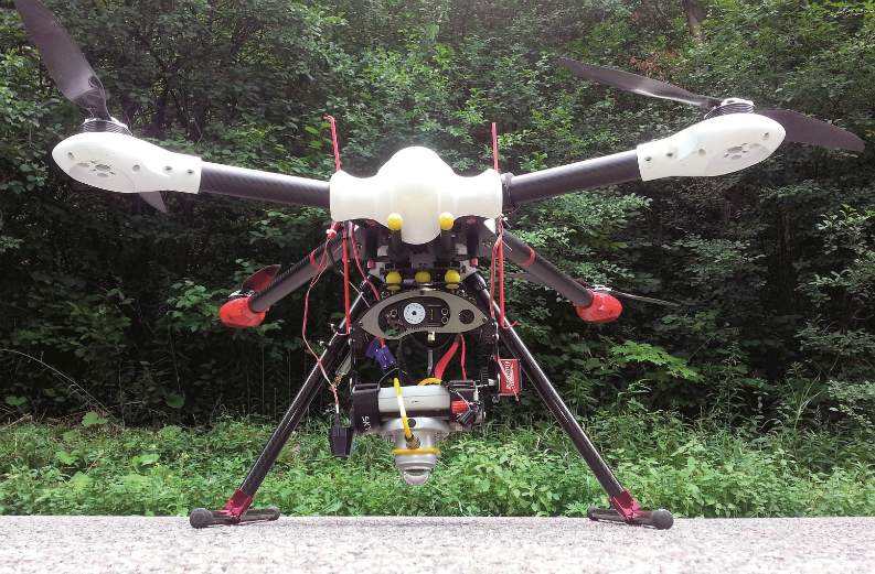
The measurement equipment
Measurements of short-wave broadband albedo were collected using Kipp & Zonen CMP6 and CMP3 pyranometers. The incoming global short-wave radiation was measured by the CMP6, mounted at the top of a 9m telescopic mast and recorded by a Kipp & Zonen METEON data logger. The downward facing CMP3 was secured to the underside of a custom-made UAV, levelled by a motorized gimble, and the data recorded by another METEON.
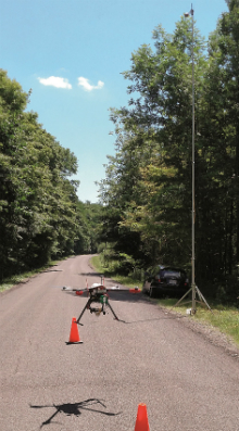
The mast holding the upward-facing CMP6 pyranometer was placed at the take-off location, approximately 200m from the final measurement point of the downward-facing CMP3, held by the drone at 120m above the ground. Albedo was calculated as the ratio between the thirty-second averages of the incoming and reflected radiation measurements by the two pyranometers.
The location was a research site in the State University of New York’s Heiberg Memorial Forest, near the town of Tully. The drone made a number of flights on 27th July 2016 of approximately twelve minutes duration. Five flights, spaced around solar noon (13:11), saw the drone at the assigned latitude and longitude and at the assigned height of 120m. Observations having interfering cloud cover, based both on local observation and on total incoming solar radiation values being below the selected threshold of 750W/m2, were removed.
The first test with a drone is promising
The flights demonstrated that the drone-mounted pyranometer was capable of taking consistent measurements of reflected solar radiation, with the resulting albedo values in keeping with those of literature for similar forest stands. Albedo measurements by drone have not, to the best of our knowledge, previously been carried out successfully; yet they offer an important opportunity to make flexible measurements over a wide spatial range.
While towers are limited in their maximum viewing area, require extensive infrastructure and are constrained to single geographic points, drone measurements might allow detailed characterization of albedo over a wide range of surface types that could be used to validate satellite estimates or to characterize conditions that satellite estimates do not sufficiently capture; such as temporary canopy snow cover, or albedo differences across biomass crop stands.
Visit www.uavimagingservices.com and the research site at www.esf.edu/campuses/heiberg to find out more