Is the equipment at fault? Or have all aspects of the site-geography, environmental conditions, and local weather conditions been considered? This article describes a situation where the measured radiation was out of the expected range and the radiation measurement equipment was presumed faulty. BKC found that by taking into account existing weather and environmental conditions for that particular geographical location, the measurements were in fact accurate.
When setting up a capital intensive solar power plant, an accurate assessment of the available solar radiation should be the first step in evaluating the energy output at a certain site. Initial estimates using historical data for a typical meteorological year (TMY) are a good starting point, but they remain just that, a starting point. For estimates of solar energy yields that can ultimately formulate bankable reports for establishing solar plants, accurate ground measurements on-site are imperative.
Along with solar radiation, meteorological parameters such as wind speed, wind direction, ambient temperature, relative humidity, and other environmental factors such as cloud cover and dust, also impact upon the solar energy available at any given site. Thus, accurate measurement of all of these parameters using high accuracy instruments is invaluable for solar project development and R & D purposes.
Through partnership with Kipp & Zonen and other leading OEMs, BKC Weathersys provides turn-key solutions for solar monitoring stations and also monitors data output for accuracy. Ground measurements can also be correlated with satellite data and advanced solar models to ensure accuracy as you will see in the case study below.
In the following case study a client with a solar monitoring station on a glacier in the Himalayas was having problems. Something was wrong with their set-up. Of late, their readings seemed way-off. Could we please look at the data and decipher what was going on?
Case Study: Reflection of Solar Radiation at Yala Glacier, Himalayas, Nepal.
A research institute had installed a solar monitoring station on a glacier in the Upper Himalayas. After a month they reported strange radiation data. The station included a Kipp & Zonen CNR 4 net radiometer; which has two pyranometers that measure incoming and reflected short-wave solar radiation, and two pyrgeometers that measure long-wave radiation from the sky and the ground.
Instrumentation
The CNR 4 net radiometer is a high quality, reliable instrument with proven performance in polar conditions. Apart from the four radiation measurement sensors, two temperature sensors, a Pt-100 and a 10K thermistor, are incorporated to correct the long-wave far infrared readings for the temperature of the CNR 4 instrument housing. In addition there were six other sensors for meteorological and environmental parameters. The data outputs from all seven instruments were fed to a RTDL-11 data logger from Real Time Solutions Pvt. Ltd. There was also a solar panel, with battery charger and controller, to power the system.
The Problem
The extra-terrestrial ‘solar constant’ of approximately 1,367 W/m² is the solar radiation expected at the boundary of the atmosphere. Under normal conditions, the global horizontal irradiance (short-wave solar radiation) arriving at the Earth’s surface rarely exceeds 1,200 W/m², whilst the long-wave radiation does not usually go beyond 400 W/m².
However, during June 2012, the measured global radiation was more than 1,700 W/m². The customer attributed the cause to faulty instrumentation and set-up. Fifteen days of data were available for analysis by BKC Weathersys.
The Solution
The data from the CNR 4 for 15 days at the Yala Glacier, Himalayas was analysed by our team. It was clear that the radiation value surged rapidly from a low level, remained at that level, and then declined to normal values, indicating that before the acceleration there must have been some cloud in the sky. Clear sky conditions remained for a short while, before cloud cover arrived again.
The incoming short-wave ‘global’ radiation and reflected short-wave radiation are shown in figure 1.
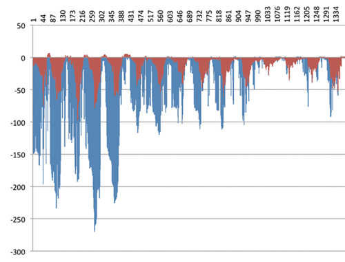
The long-wave radiation from the sky and long-wave radiation from the ground are shown in figure 2.
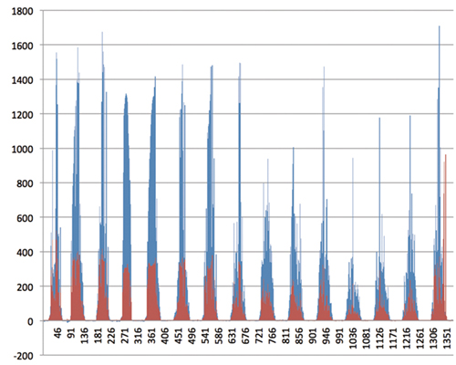
The reason for the sharp rise in radiation is because the cloud acted as a mirror, reflecting sunlight to the sensor and increasing the reading compared to a clear, diffuse sky. This happens at high altitudes with a clear sky and some bright white cumulus clouds (not covering the sun) and can result in global radiation values exceeding the solar constant, up to more than 1,400 W/m². To reach a measured irradiance of 1,700 W/m² requires another effect.
The monitoring station is installed on the slope of the glacier with snow covered rock above it. This means that the upper sensors of the CNR 4 see not only the sun and sky, but highly reflective surfaces that are producing irradiance much higher than the diffuse sky normally seen by a pyranometer or pyrgeometer. The reflection can be up to 80% of the incoming radiation, depending upon the type and age of the snow and ice. In summary, we concluded that the radiation data being measured at Yala Glacier was accurate and within range for the location.
Conclusion
This case study shows that local geography, site topology, meteorological parameters, and environmental conditions have a big impact on the measured solar irradiance. All of these factors need to be taken into consideration when validating the final derived data.
This study endorses the use of ground observations at the selected site as the most appropriate and accurate method of carrying out such research or resource assessment. Our analysis enabled the research institute to not misdirect resources towards fixing ‘faulty instrumentation’ when other conditions accounted for the seemingly out of range data, which was, in fact, correct and real.
By Dr. Jaya Singh, BKC Weathersys Pvt. Ltd. of New Delhi, the Kipp & Zonen distributor for India.