The interest in monitoring heat fluxes, the energy balance and evapo-transpiration is growing world-wide.
This is fuelled by the increasing need for the efficient management of drinking water and improving weather forecast models to predict extreme weather. EARS (Environmental Analysis and Remote Sensing) is a Dutch remote sensing company. They have developed a novel Energy and Water Balance Monitoring System which utilises Kipp & Zonen Scintillometer systems for measuring sensible heat flux and evapotranspiration.
Novel water management techniques
The Yellow River, or Huanghe, is the second longest river in China. It has its source in China’s far West. It loops North, bends South, and flows East for approximately 5,500 km until it empties into the sea, draining a basin of 745,000 km², which nourishes 120 million people.
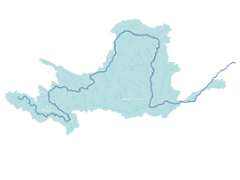
In the past 10 years the Yellow river has frequently dried up due to insufficient information and lack of control on water distribution. Current hydrological models are sophisticated, but their performance is restricted due to lack of input data. Current measuring stations are too far apart to create a fair representation of the rainfall field.
EARS, has developed the Energy and Water Balance Monitoring System (EWBMS). This system is currently being used in China to predict the Yellow River run-off and to measure the distribution of drought in the Yellow River basin on the basis of satellite data. With this information the scarce river water resource can be allocated in a cost-effective and efficient way. The system will also be used for high water forecasting and will be able to provide daily rainfall maps of the basin at 5 km resolution. Moreover, this system is the first in the world to map the evaporation of water from the Earth’s surface.
Validation of satellite data using Scintillometry
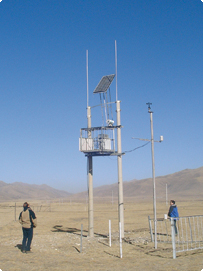
In the implementation of EWBMS, validation of the satellite output plays a vital role. In China this is performed using four Large Aperture Scintillometer EvapoTranspiration Systems (LAS-ET) from Kipp & Zonen. These systems provide near real-time measurements of the path-averaged sensible heat flux, net radiation and evapotranspiration over a path of approximately 5 km, which approximates to the pixel size of many satellite systems. Therefore, the measurements from a LAS-ET system can be used to validate (ground-truth) satellite data measured over the same locations from space.
The Scintillometer method of deriving evapotranspiration
A scintillometer measures fluctuations in the density of the air. These fluctuations are caused by heat and moisture fluxes exchanged between the earth’s surface and the lower part of the atmosphere. Combined with standard meteorological measurements, such as wind speed, temperature and pressure, the sensible heat flux is derived. Additional measurements of the net radiation balance and the soil heat flux yield the evapotranspiration.
The Kipp & Zonen LAS-ET system provides an all-in-one solution. It contains all the required measurement instruments and data acquisition. The specially developed EVATION© software package offers a very user-friendly interface for storing and processing all the measured data, with graphical representation available at the click of a button. Kipp & Zonen can provide extensive technical support due to years of experience in the field of scintillometry.
For more information on the EWBMS please visit EARS at www.ears.nl