Strangely enough, solar energy is not yet part of the discussion. You would assume that there is a lot of solar radiation available, especially in the Northern part of the country. The climatic conditions are perceived to be better than in many other locations around the world where solar energy conversion systems are in use today.
Mr. Alberto Ortega, assistant researcher and advisor in Scientific and Technical Management, and Rodrigo Escobar, Mechanical Engineering professor, both of the Pontificia Universidad Católica de Chile, are the project leaders in the Solar Resource Assessment for Chile.
Ortega says that “A proper atlas of solar energy, with actual data of low uncertainty is not available to the public or to planning authorities. This is part of the reason why solar energy has not been considered in Chile as a major energy source. There is no bankable data that could help gather the required financing that large-scale projects need.”
 They have reviewed and analyzed the available solar energy data of ground stations from several sources and compared them to satellite derived measurements obtained by the Brazilian National Institute of space research, INPE, and weather simulations from Universidad de Chile.
The available ground-station information comes from three different sources: A database of measurements from 89 stations throughout Chilean territory from 1961-1983; Data from the Chilean Meteorological Service from 1989; A network of stations at Pozo Almonte, San Pedro de Atacama and Crucero that collect data for the Chilean Comisión Nacional de Energía (CNE).
Each CNE station utilises three Kipp & Zonen CMP 11 pyranometers, a data logger, wind speed and temperature probes. One pyranometer measures global horizontal irradiance and the remaining two are mounted on a simple solar tracker. The first measures the tilted global irradiance and the second measures the tilted diffuse irradiance by being covered with a shadow ring. Although this set-up is non-standard, and the data requires extensive post-processing, it nevertheless allows an estimate of the direct normal irradiance (DNI) with a reasonable degree of uncertainty, which is useful to assess solar energy potential.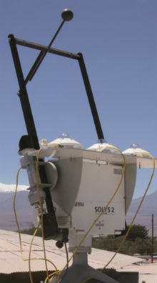
There are locations in Chile for which data is available, but of varying quality and with interrupted periods of time. However, large regions of the Atacama Desert (in the Northern part of Chile) have no ground-station coverage and no solar radiation measurements. This is right where it is supposed, and widely discussed, that the best solar energy potential is located.
The team led by Ortega and Escobar is focusing on the development of a remote measurement technique based on satellite image processing. “The methodology works with a radiative energy transfer model in the atmosphere, utilizing climatic parameters (temperature, relative humidity, visibility, ground albedo and topography) to determine the aerosol profiles in the atmosphere.
Satellite images in the visible and infrared channels are processed as an indication of how much radiative energy is leaving the atmosphere. A special treatment allows us to detect and classify the optical properties of clouds, and the final product is an estimation of global horizontal, diffuse horizontal, and direct normal irradiance at the earth´s surface”, explains Escobar. This work, developed in collaboration with INPE, Abengoa Solar NT, the Chilean Meteorological Service and the Military Geographical Institute, aims to produce solar radiation maps for the whole country which will be published in an atlas by 2012.
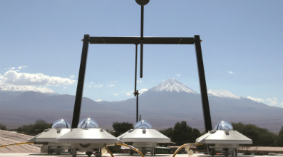
The satellite-derived data needs to be validated by accurate ground station measurements. The team is deploying several Kipp & Zonen stations around the country, all of which are composed of SOLYS 2 sun trackers, CMP 11 Pyranometers, CHP 1 pyrheliometers, CGR 4 pyrgeometers and CUV 5 Ultraviolet radiometers. “The ground measurements are used to validate the satellite estimation model, and also provide valuable data in proper temporal resolution. We have chosen Kipp & Zonen as it offers accuracy and reliability”, explains Ortega, while mentioning that several of the ground stations are deployed in hostile environments such as the Atacama Desert - the driest in the world.
Mr. Ortega believes that the adoption of a proper solar atlas will result in an enhanced ability for the analysis and design of solar energy systems, thus allowing accurate project estimations. This is perceived as the first step towards the large-scale utilisation of solar energy in Chile for power generation, industrial, commercial and residential heat supply, and solar-assisted cooling.