The Andes reach over 6,900 m above sea level and the Chilean coastal range beyond 3,000 m. Though not an isolated case, a clear example of the effects produced by microclimates is the ‘Camanchaca’, a thick coastal fog that occurs in the morning at low altitudes near the coast in the northern part of Chile. This fog helps to create places like the Fray Jorge Forest where, in a dry Mediterranean climate area, one can see the northernmost Valdivian temperate rainforest.
From the point of view of a solar and wind energy developer, this is challenging. Currently, the biggest source of uncertainty for large scale PV development comes from the input data. Chile has very few ground stations with high quality irradiation measurements. This forces many developers to use satellite data and solar models with very little validation. The satellite data and modelled data are typically validated via high quality ground stations. However, these are scarce in Chile and leads to high uncertainties in quantifying the long-term solar resource. This means that planning and executing a high quality measurement campaign is essential for minimizing uncertainties and giving investors comfort in the accuracy of the yield of the solar plant.
 Mainstream is developing several PV projects in Chile, in total around 350 MW. It was clear from the start that the best way of addressing project risks was to carry out our own high quality solar radiation and meteorological measurements. This ensures that all our projects have high quality measured data that can be used with confidence in financial models.
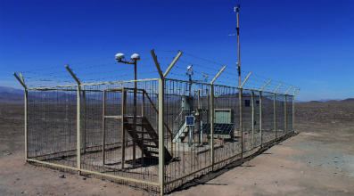
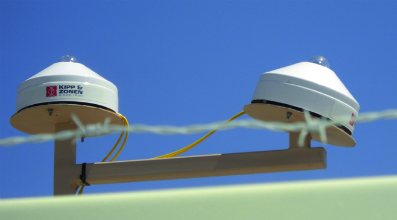
Our measurement stations typically use two Kipp & Zonen CMP 11 pyranometers to measure irradiation, both with CVF 3 ventilation units. We use one pyranometer in the horizontal plane and another inclined in the same plane as the panels will be once they are installed. This adds some redundancy to the measurements and also allows us to reduce the uncertainties in the transposition models used. The CVF 3’s ensure that we minimise suspect data due to condensation and also reduce somewhat the need for pyranometer cleaning due to accumulated dust. We also measure other atmospheric parameters such as wind speed, wind direction, humidity and temperature.
 We ensure that the equipment is regularly maintained and have local contractors servicing each station several times a week. They clean the domes of the pyranometers and the solar panel that powers the data logger and the ventilation units. They also check the silica gel desiccant in the pyranometers and the CVF 3 inlet filters once a month, to monitor if they need replacements and in very remote areas they can download data to ensure we are able to carry out regular checks of the measurements.
We are aware that most of the ground stations operated locally do not follow such strict standards regarding data quality and often do not have any form of a maintenance record log. As a result the consistency and accuracy of these datasets is often questionable and in addition there is higher uncertainty in the measurements. The pictures below show the effect of not cleaning pyranometer domes regularly.


By using equipment of the highest accuracy and regularly maintaining it, we are obtaining quality datasets with the very low uncertainty that is critical to successful solar project development.
Find out more about Mainstream Renewable Power at mainstreamrp.com.